
MSU Capstone Projects : Technology for Conservation
Senior capstone projects at Montana State University are aimed at helping students develop and use skills they’ve acquired over the last four years of their education. YERC partners with MSU to provide real-world experience to students in the context of technology for conservation. Student groups worked hard to overcome technical, mechanical, and software challenges throughout their projects but the groups were able to configure functioning prototypes that met the requirements set by Robert Crabtree and Roby Roberts.
The projects ranged in purpose and each group was made up of different disciplines of engineers and computer science majors. Ultimately, the projects were designed to help conservation efforts through creative technologic innovation.
Happy seniors with their final project and academic poster!
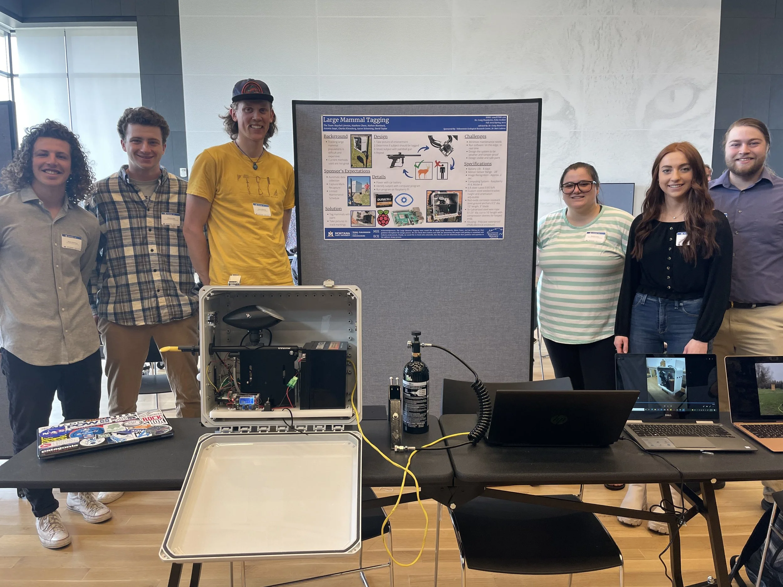
Large Mammal Tagging
The large mammal tagging group consisted of team members Raychel Limnios, David Taylor, Matthew Chase, Antonina Seppi, Charlie Kinneburg, Aaron Schoening, and Nathan Blomback. The group was assigned the task of creating an automatic system that uses the capture-mark-recapture animal tagging method to estimate population sizes of large mammal populations. The final product consisted of a motion sensitized paintball gun that recognized large ungulate species and automatically took photos and shot paintballs to mark wildlife - “tagging” them for recapture by a game camera.
The group finished with a working prototype after hard work overcoming design challenges. The biggest issues were related to implementing software that recorded the data and recognized the shape of the target species. Additionally, the group needed to experiment with various paint mixtures that could successfully mark an animal, but also be non-toxic.
Handheld RFID Fish Scanner
John Winfield, Isaak Bell, Macager Mcallister, and Noah Cleary designed and developed a RFID scanner that can be easily transported to the river, but at the fraction of the cost of similar products on the market. The group designed the scanner for the use of everyday fishermen that can help in tracking fish movements, return rates, and population. The user simply puts the scanner in close proximity to the fish and the device reads the RFID tag. The group plans to further the design by making it much more compact, therefore possibly making it integrated into the frame of a fish net to form a cohesive unit.
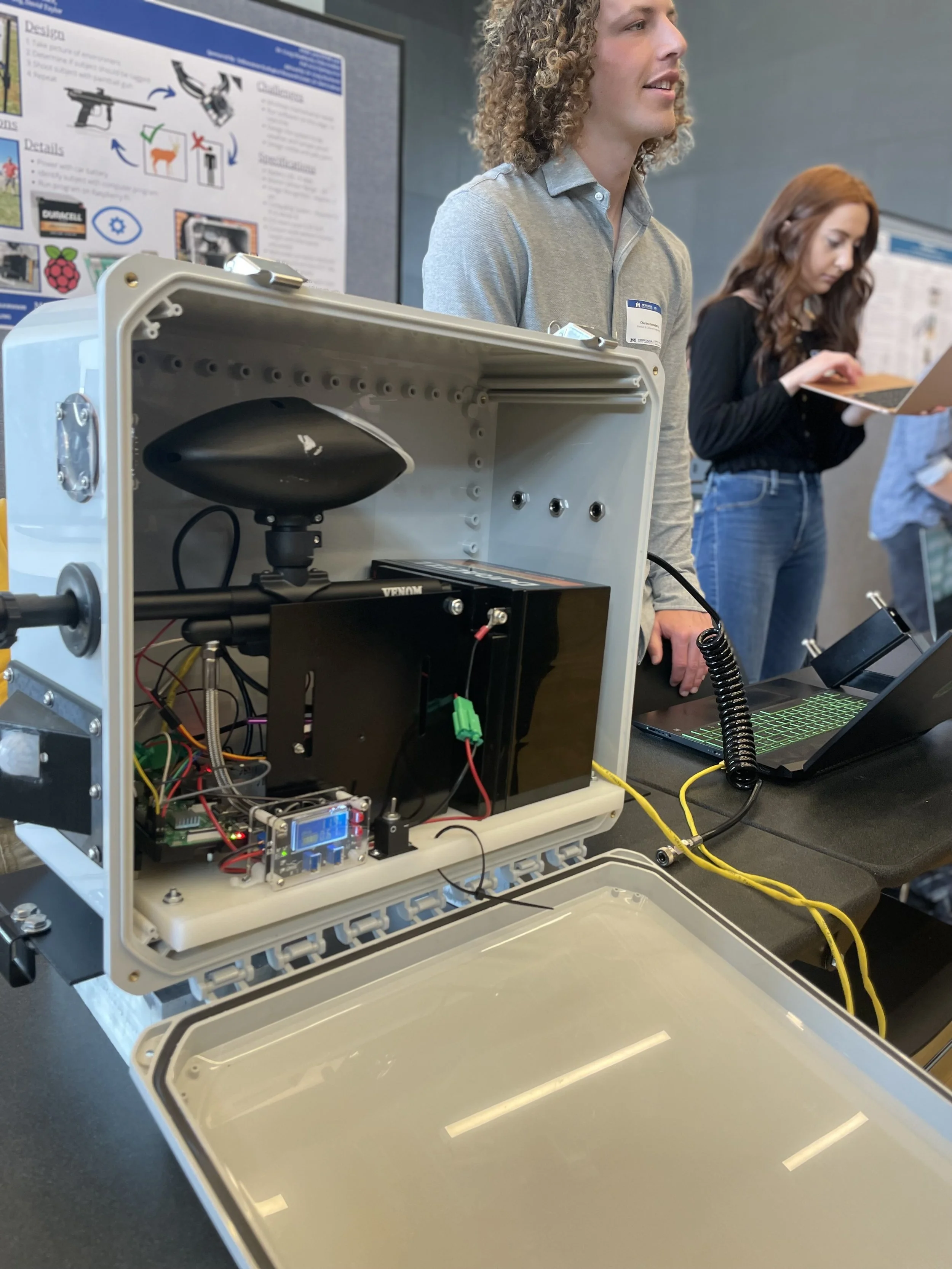
The large mammal tagging group’s final prototype.
Aerial Predator Deterrent
Riggs Ferguson and Spencer Scamman made up the first half of the Aerial Predator Deterrent team which focused on helping ranchers and other property owners deter predator species such as bears, coyotes, and wolves from their livestock. This project was inspired by the Anderson Ranch located in the Tom Miner Basin, which boasts the highest density of grizzly bears in the lower 48 states. The team was tasked with building a rotating camera system that can be mounted to a drone. The system would allow landowners to remotely record and scare predators with olfactory, auditory, and visual deterrents. The camera would send back live video to the user and also included a level of encryption for security.
The second part of the team designed the drone that would carry the camera and deterrents. The drone needed to be stable enough to carry a fairly heavy payload of bear spray, an airhorn, and lights across considerable distances. The team struggled with electronic components of the drone and managing the payload, but the toughest challenge to overcome was integrating the flight controller software. Using an MSU drone, the team created a working prototype that is able to fly, record video, and spray bear spray!
GIS Team
The GIS team was tasked with creating maps that showed detailed topography of the Yellowstone River terrain. The team, TJ Wilkerson, Cy Halvorson, and Tyler Trogden, overcame various technical challenges to map the territory. They hand categorized each portion of land, differentiating fields, stream area, and wooded areas to create a map that communicates the various terrains surrounding the Yellowstone River. These data layers will support YERC’s RiverNET program.
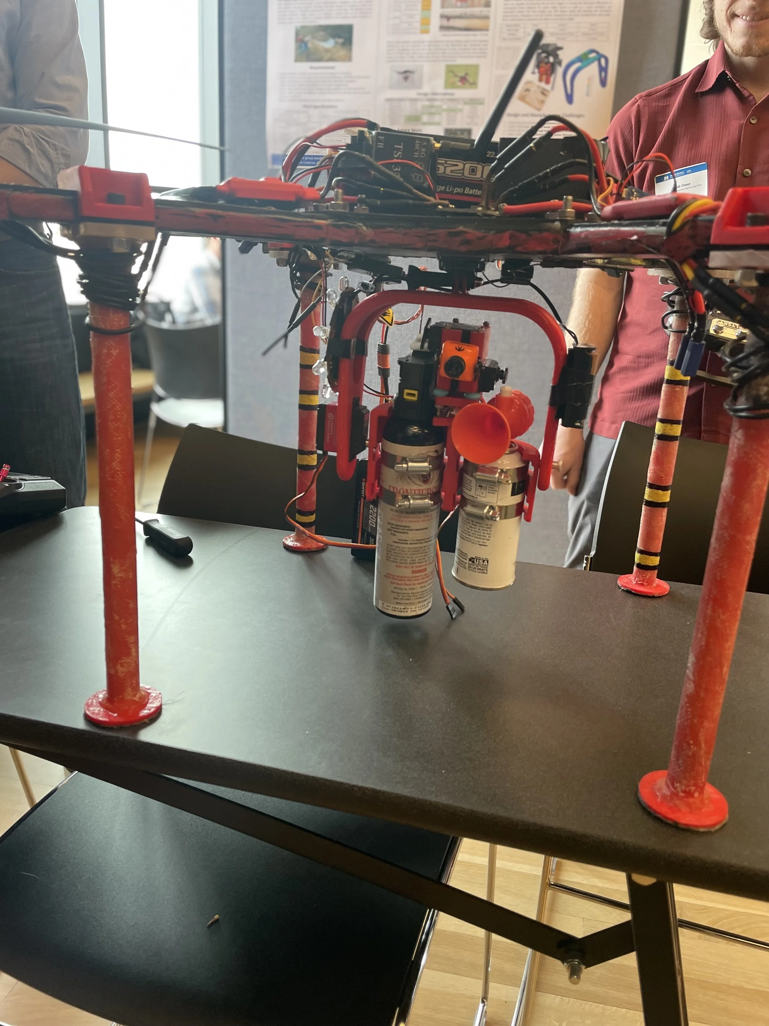
The final prototype of the predator deterrent drone.
EPIIC App
The computer science team was focused on creating an application that can make YERC data come to life for users. The team, Hannah Madsen, Kieran Ringel, Grayson O’Leary, and Tali Eigner, worked towards making a mobile application that can show timely data in helpful ways. The app needed to be accessible and updateable from the backend. This app will provide important visuals to help users access data YERC’s RiverNET data from aquatic insects to discharge and water quality data.