
Semester wrap up - Montana State University student groups
The YERC team would like to extend a huge thank you and congratulations on a great semester to our Montana State University Student groups that are working to develop and implement next-generation conservation technologies. They have put in some hard work this fall in the design phase, and we are looking forward to seeing the realization of their projects next semester. We also greatly appreciate the MSU faculty and staff as well as RESOLVE, a key NGO sponsor with years of conservation successes.
Spotlight: Smart FishNET
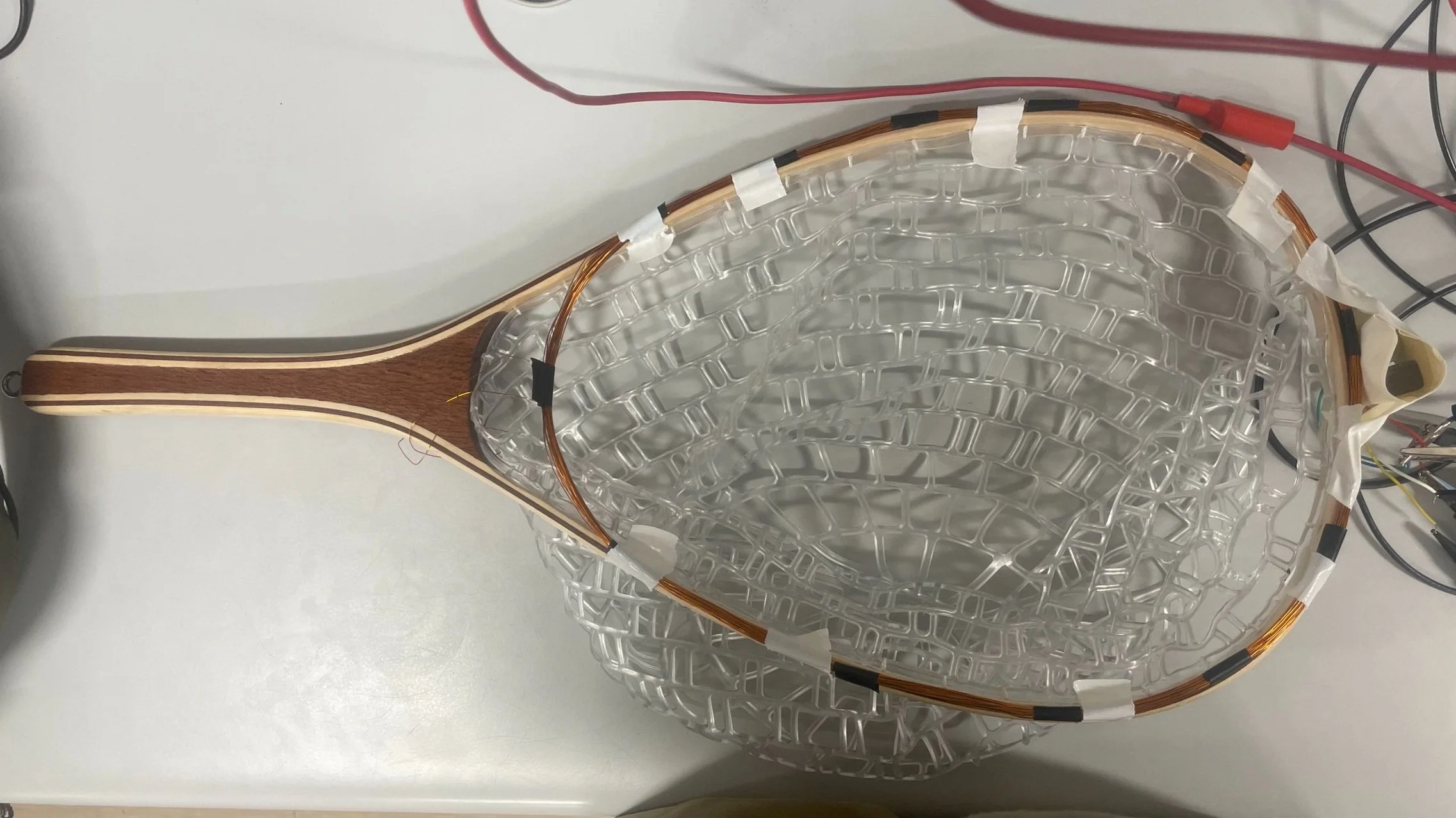
The FishNet prototype, with the RFID scanner (ring of bundled copper wires) attached to the rim of the net.
Imagine this: as you wade through the brisk river on a warm July evening, you scan the rapids for an ideal spot to try your luck. After selecting the appropriate fly, you settle into the familiar rhythm of fly fishing. After a while, you feel a tug, and begin to land your fish. “Finally,” you mutter, and revel in the excitement of the catch. You reach for your landing net, and scoop your fish gently into the net. When the landing net contacts the water, a free and simple app on your cell phone is activated, and an indicator light on the handle flashes. This one is tagged! Water temperature and tag ID number is wirelessly transmitted to your cell phone and the cloud while your prize trout is still in the water. This special landing net system allows sport anglers to help collect data on fish populations, which is compiled into YERC’s community database where it can then be analyzed by experts and examined by civilians.
After gently untangling the hook from the fish’s mouth you take a cell phone picture of it next to the net to determine length, verify species and condition, and you set it free. You stand for a moment, admiring the peace of the Yellowstone River and the beginning of the sunset behind the Gallatin Range. When you return home tonight, you can take pride in the fact that you have not only had a successful day of fishing, but you have contributed sound data that will help scientists stabilize, sustain, and manage fish populations so that one day, you can teach your children to fly fish alongside you.
This semester, the FishNET team worked to design an RFID (Radio Frequency Identifier) scanner that is integrated into the rim of a handheld fishing net. Their design process is coming to an end this week, when they will present a prototype to their academic mentors. After a few potential edits to the design based on feedback from professors and YERC staff, the team of 4 will be off to a strong start in creating a functioning final product next semester.
The technology that they are developing will allow sport anglers to become citizen scientists with every catch! Trained biologists insert a tiny PIT tag (Passive Integrative Transponders) in a sample of fish which allows them to be recognized with an RFID scanner upon recapture. The number of tagged fish compared to untagged fish is used to estimate fish population size, survival, growth rate, distribution and seasonal movements. With the FishNET technology, sport anglers will be able to contribute to highly valuable recapture data, which uploads to the YERC mobile app via bluetooth technology. The main design questions that the group is working on are waterproofing the RFID scanner (a bundle of wires) that will go all the way around the rim of the net, ensuring the net’s compatibility with YERC’s mobile app, and maximizing battery life by automating the conditions in which the scanner turns on.
Other Projects
Large Mammal Tagging
The Large Mammal tagging group is completing their semester with a functionally complete design that is vastly improved from last year’s prototype. Their mounted paintball gun that is triggered by RESOLVE’s camera trap with built-in AI that senses movement of an approaching animal and then determines whether the image captured is a target species so there is zero chance of it being a human. The system then marks the main body area with a unique temporary paintball mark captured in a verifying image. The team is working on ordering a list of components in order to build this next-generation working prototype. They have retained many of the materials off of last year’s prototype, but need to replace some parts to account for design changes. These changes include a tree mount instead of a T post and a substantial reduction of its size and weight. The major innovation in this prototype is the integration of RESOLVE's new TrailGuard 2B trail cam - arguably the top most powerful camera trap on the market. The four mechanical engineers on this team were challenged to learn some electrical engineering skills in order to complete their project - and with help from accommodating professors, the team is well on their way to creating a system capable of non-invasive marking for key management concerns: accurate estimation of population size and identification of problem individuals. This technology will enable adaptive management of large mammal populations - a key to ecosystem health and integrity.
DIABLO
The DIABLO (Drone In A Box for Large-scale Optimization) team has had a highly successful design semester, and are on track to order supplies at the end of this semester in preparation for the assembly and execution phase next semester. They may make further changes if they encounter issues upon construction of their Sky Box, but their initial planning process is complete. Upon remote AI detection of a ‘target’ species of interest, a drone is automatically launched with spatial coordinates to follow the target. It can send alert and reconnaissance updates and automatically return home. Integral to the system is RESOLVE’s TraiGuard camera and communication systems. The team of 4 mechanical engineers and 4 electrical engineers are working to ensure that the Sky Box (where the drone will be housed) will be able to fit, charge, and deploy the drone while ensuring waterproofing capabilities, and cell phone communications between all the parts: drone, RESOLVE camera, YERC app, the Sky Box, and humans making decision if necessary!
GIS
The drone imaging remote sensing group has successfully completed their drone flights this fall. Their field activities involved floating down the Yellowstone river to access their study areas! They are currently creating a 3D model using the images they collected. The ‘data maps’ that this provides - vegetation height above ground and habitat types - will also allow the team to perform a sediment flux analysis in the future. This analysis will compare this year’s spatial data to last years, and will therefore determine where, and in what quantities sediment was redistributed along the Yellowstone river in the flood earlier this year.